
Sediment Monitoring for Citizen Based Monitoring Groups
By Erin Wall and Adam Sigler - MSU Extension Water Quality
Version 1.0 Updated 2/1/2016
/
+ Monitoring Objectives to Inform Method Selection
Before a monitoring plan can be developed, monitoring objectives must be clearly defined.
Objectives will determine what parameters and methods are most appropriate to obtain
useful, credible data. Eighty seven percent of 2014 survey respondents said that citizens
and non-DEQ personnel can play a role in sediment monitoring if there are sediment
impairments in the streams they monitor. In order for citizens and non-DEQ personnel
to play a role, there must be a specific question to answer or goal for monitoring,
such as effectiveness of a restoration project or identification of sediment sources.
Sediment related monitoring methods fall into two main categories: 1) water column
measurements and 2) channel or substrate characterization methods. Perhaps the most
common water column sediment measurement in natural streams is suspended sediment
concentration (SSC). This type of water column measurement is strongly influenced
by discharge, so it is typically necessary to have discharge information collected
at the same time. It is also typically necessary to collect water samples at different
flow levels to begin to understand sediment transport behavior in a stream. In contrast,
physical (channel or substrate) characterization methods can often be conducted as
few as one time per year and can provide information about sediment dynamics over
a period of time preceding the measurement. Pool tail fines for instance can provide
information about the amount of sediment that has been deposited since the last high
flow event. Physical channel measurements are also typically more directly related
to habitat suitability for fish and macroinvertebrates which are often an important
motivation for monitoring.
Montana DEQ has largely moved away from water column type sediment measurements and
instead relies on physical characterization of streams in order to assess sediment
impairment. It is possible to modify standard MDEQ methods to make them more feasible
for volunteers, but the modified methods may not produce data suitable for regulatory
or compliance monitoring. The data produced from modified methods are more suited
for making local management decisions or determining sites for restoration projects.
In the 2014 survey, almost 90% of participants from watershed groups said that they
are very interested in using sediment monitoring to assess effectiveness of restoration
practice implementation. With the variety of sediment related methods available, identification
of clear objectives for data use is critical to determine which methods are appropriate.
+ Monitoring Methods
+ Water Column Measurement Approaches
+ Suspended Sediment Concentration
Suspended Sediment Concentration (SSC) is the measured dry weight of all sediment
from a known volume. SSC is made up of suspended material eroding from banks and/or
from overland flow which is highest during snow melt or storm events. SSC should not
be confused with Total Suspended Solids (TSS), which is similar but notably different
analytically. TSS is the measured dry weight of sediment from a known volume of a
subsample from the original sample. The subsampling method systematically eliminates
the coarse fraction (sands) from the sample which is why it cannot be directly compared
to SSC. The method for TSS was originally developed for wastewater that has already
gone through a stage of settling, so it is not ideal for surface water.
There is typically a correlation between SSC and turbidity, so SSC samples collected
concurrently with turbidity samples can be used to quantify the relationship. Over
time, a rating curve can be created by plotting a regression between SSC and turbidity
measurements which allows SSC to be estimated from turbidity. This requires a sampling
design to collect samples at different flow levels and with different sediment concentrations
to produce a useful rating curve. This type of undertaking can pay off for long term
efforts because turbidity data is very low cost (after meter purchase) while SSC sample
analysis may cost $40 per sample.
+ Turbidity
Turbidity refers the cloudiness of (or light deflected from) the water which is primarily related to the amount of suspended sediment in the water. There are two approaches for measuring turbidity: 1) a secchi disk approach or 2) a turbidity meter. The secchi disk approach is parallel to the method used in lakes except a tube is filled with stream water and the checkered disk (secchi disk) is lowered into the tube until the pattern can no longer be observed. The depth below the surface where the disk disappears is recorded as the secchi depth. A smaller value for secchi depth means the water is more cloudy. The second approach uses a meter. The sample is placed inside and light is shined at the sample while a sensor measures how much light is bounced off the sample. Results are typically given in NTUs (Nephelometric Turbidity Units) where larger numbers mean more cloudy water. After the initial cost of the meter, samples can be analyzed quickly at low cost with reasonable accuracy. Analysis can be conducted in the field if the meter is brought along or samples can be transported back to an office or lab for analysis.
+ Physical Channel or Substrate Characterization Approaches
Physical characterization approaches include direct observations of the channel or substrate and provide insight about bank erosion rates (or risk) or sediment deposition in the channel. Unlike the water column measurements, these metrics provide information about sediment dynamics over longer periods of time than when the observer is there. Physical metrics are also tightly coupled with habitat characteristics important for aquatic organisms, so can be directly related to ecosystem health. Physical metrics often only need to be evaluated once a year and typically during base flow in the late summer or fall when it is safer and can be more pleasant to be in and around streams and rivers.
It is important to note that the sediment assessment methods outlined here are for wadeable perennial or intermittent mountainous streams in western Montana. Methods for larger rivers and eastern Montana’s prairie streams have not yet been adopted by MDEQ. For more information on these methods, refer to the MT DEQ Western Montana Sediment Assessment Method document.
+ Pebble Count

The pebble count determines the percentage of surface fines in a riffle. Riffles provide winter habitat for juvenile salmonids and are susceptible to sedimentation. The MDEQ pebble count method requires a minimum of 400 particles (pebbles) be collected. The Gallatin Stream Team has adopted the MDEQ protocol while the Madison Stream Team has adopted a modified method that collects 100 pebbles in a slightly different format. The Gallatin approach provides the opportunity for stream team data to be more directly compared with MDEQ data and to sediment substrate standards. The Madison approach is able to be conducted more quickly and while the results cannot be directly compared with MDEQ results, they can provide insight about large magnitude differences in fine sediment among stream reaches or large changes over time.
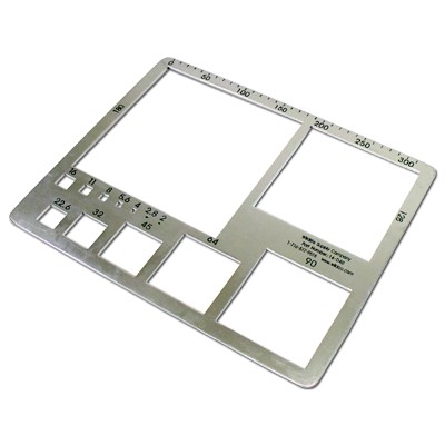
A gravelometer is a piece of equipment used to measure particle size and is less subject to human error than the traditional approach of using a ruler. It is simply a flat sheet of metal with different sized square holes in it. The largest hole that the pebble will pass through is recorded for each pebble. The resulting data assigns each pebble to a size class rather than providing a specific size for each particle.
+ Pool Tail Fines
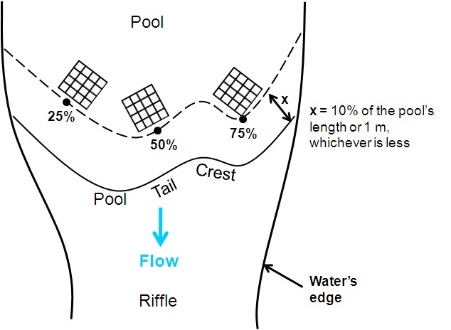
Pool tails are important places for salmonid spawning, and fine sediment deposition in these areas can smother spawning gravels. Fine sediments are defined in MDEQ methods as particles that are less than 6mm across. "Pool tail fines" is the percent of the pool tail surface covered with fine sediment and this is quantified using a "grid toss". The grid is laid out in three locations across the pool tail and has 49 intersections which allows for a systematic observation of 147 (49x3) locations for sediment size (greater than or less than 6 mm). There is nothing magic about the number 49 or 147, it is simply a convenient grid design that has been adopted. There are specific guidelines on how the grid is placed and what constitutes a pool for making observations in. A plexiglass viewer is often used to make it easier to see the sediment at the grid intersections under the water surface.
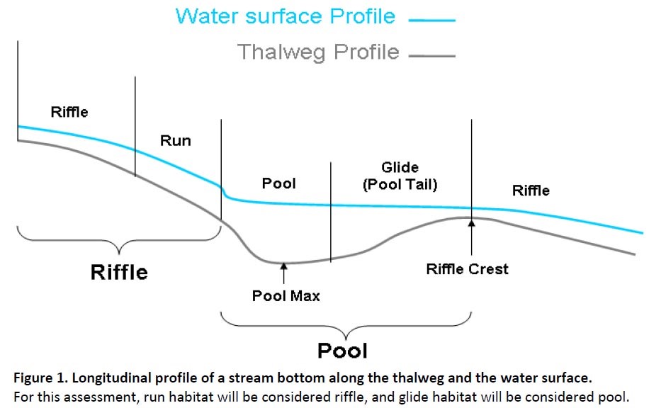
+ Residual Pool Depth
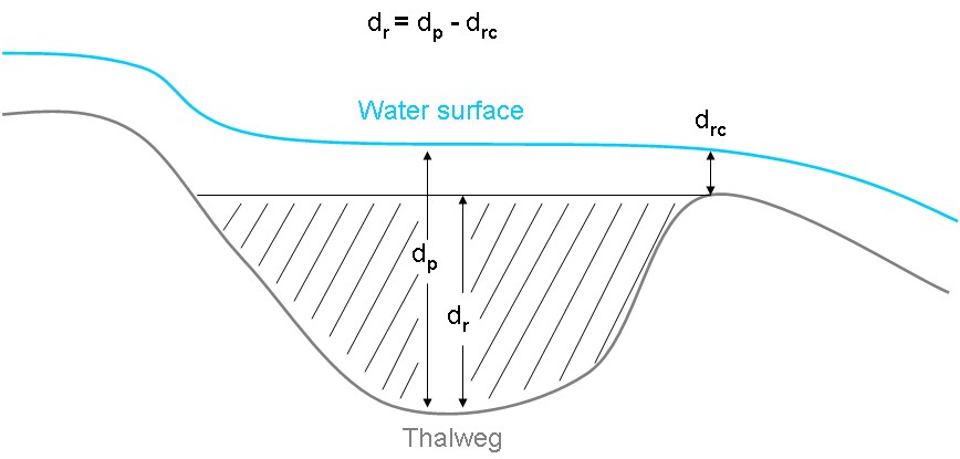
Residual pool depth describes the minimum amount of pool habitat that would be available regardless of how low the flow gets (it is independent of discharge). It is the depth of the pool at the deepest point minus the depth at the riffle crest. This is basically the depth of water that would be left in the pool if the stream flow were suddenly completely turned off.
+ Site Selection
Site selection will depend on the goal of the monitoring and the monitoring methods that will be used. Site selection for water column measurements typically includes consideration of where tributaries join a stream and where changes in land uses occur. While sediment sample collection can be conducted with specialized equipment, simple grab samples are often used. This means there are not a lot of requirements for access, aside from being able to reach a well-mixed portion of the stream. A sampling stick can be used to extend a sampling bottle into the water from a bridge or other safe location.
Identifying sites for physical measurements first requires a big picture assessment of which stream segments are most likely to experience sedimentation. Steeper, narrower segments of streams are less prone to sedimentation than lower gradient, wider stream segments and the later type of reach is typically targeted for assessment. This is because, if there is not a sediment issue in the more vulnerable segments of a stream, there are not likely to be sediment issues in the steeper, narrower segments either. Beyond the selection of the segment of stream to monitor, specific observations about bankfull elevation and channel features also need to be made to determine where to make measurements. Repeatable identification of these stream features requires significant training and professionals can often come to different conclusions unless they have trained and spent field time together to enhance consistency. Properly training volunteers to accurately identify channel features would be a significant investment of time for the trainers and volunteers. Seventy three percent of survey participants agreed that having professionals identify reaches and channel features and training volunteers on how to collect data would be a more efficient approach than training volunteers to select reaches and identify features on their own. This initial investment can help volunteers become more confident in the methods and over time, those volunteers could identify potential reaches and features on their own.
Site selection for assessment of BMP implementation effectiveness naturally centers on the reach where the BMP is implemented. However, a good understanding of the magnitude of anticipated effect from the BMP and whether there is a reasonable chance of measuring that effect above the natural variability in a stream requires a detailed evaluation of the specific stream and project.
+ Resources
Interested in starting a sediment monitoring program in your watershed?
MSUEWQ has equipment that watershed groups can borrow to start sediment monitoring efforts. Contact MSUEWQ at (406) 994-7381 or extensionwater@montana.edu for more information.